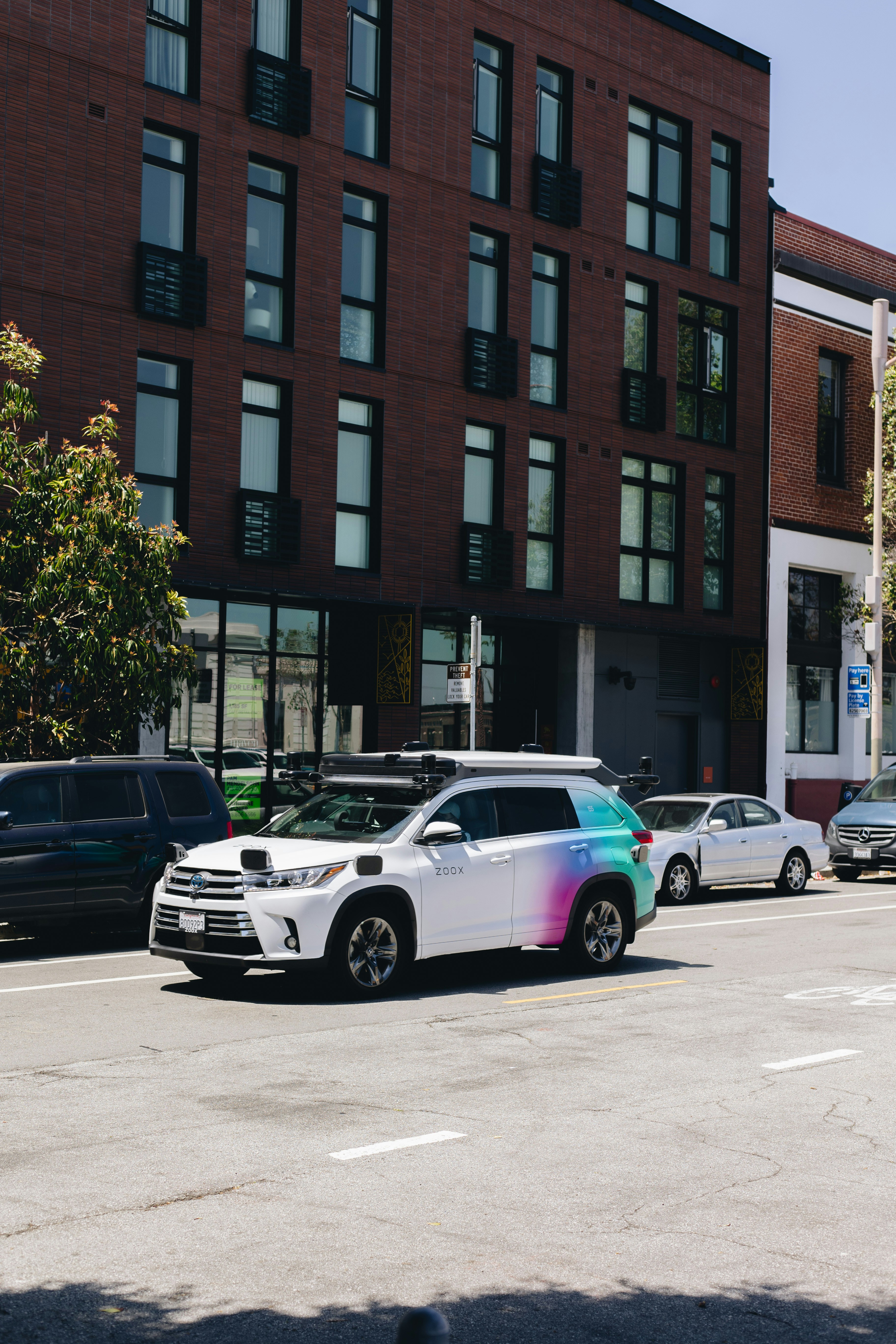
Introduction to Autonomous Driving Sensors
Autonomous driving technology relies heavily on a sophisticated array of sensors to navigate, identify obstacles, and make decisions in real-time. This technological advancement involves integrating various sensor types, each with unique functionalities that contribute to the overall efficacy and safety of self-driving vehicles. Key sensors employed in this domain include radar, cameras, and LiDAR.
Radar (Radio Detection and Ranging) sensors utilize radio waves to detect the distance and speed of objects around the vehicle. This technology is particularly effective in adverse weather conditions, where visibility is compromised, making radar a vital component in ensuring reliable distance measurement for other vehicles and obstacles.
Cameras, on the other hand, are crucial for interpreting visual cues from the environment. They capture detailed images and video, enabling the vehicle to identify traffic signals, lane markings, pedestrians, and various other elements crucial for safe navigation. The combination of images taken by cameras is analyzed via sophisticated algorithms to discern and understand the vehicle’s surroundings.
LiDAR (Light Detection and Ranging) sensors stand out due to their ability to create high-resolution, 3D maps of the environment using laser light. This technology allows for precise mapping and object detection, which is especially helpful in discerning the topology of the environment and distinguishing between different objects in proximity to the vehicle.
The integration of these sensors forms a comprehensive perception system that is vital for the functionality of autonomous vehicles. Each type of sensor brings its strengths, enhancing the vehicle’s ability to navigate safely and effectively in a variety of driving conditions. Understanding these differences is essential in evaluating the overall performance and reliability of autonomous driving systems.
What is LiDAR Technology?
LiDAR, which stands for Light Detection and Ranging, is a sophisticated technology that employs laser light to determine distances between the sensor and various objects. By emitting rapid pulses of laser light and measuring the time it takes for these pulses to bounce back after striking an object, LiDAR systems can create detailed three-dimensional maps of the environment. This measurement technique allows for high precision in distance calculations, making it an invaluable resource in various fields, including autonomous driving.
A LiDAR system typically consists of a laser source, a scanning mechanism, and a receiving unit. The laser source emits light pulses at a high frequency, often in the near-infrared spectrum. The scanning mechanism is responsible for directing these pulses in different directions, allowing the system to cover a wide area. Lastly, the receiving unit captures the reflected light, which is used to calculate the distance to each point, enabling the generation of accurate and detailed environmental models.
LiDAR technology extends beyond its application in autonomous vehicles. It is commonly used in geospatial mapping, environmental monitoring, forestry management, and even archaeology. For instance, in forestry, LiDAR can be utilized to assess tree heights, canopy density, and terrain structure. In the realm of urban planning, it aids in creating accurate digital elevation models and infrastructure designs. These diverse applications highlight the versatility and robustness of LiDAR technology, reinforcing its critical role in modern mapping and modeling tasks.
The Functionality of Standard Cameras in Autonomous Vehicles
Standard cameras have become integral components in the implementation of autonomous driving technologies. These devices primarily operate by capturing high-resolution images from their surroundings, providing essential visual data for onboard systems. The functionality of these cameras relies on their ability to process and analyze visual signals in real-time, which is crucial for decision-making processes in self-driving vehicles.
One of the key capabilities of standard cameras is their proficiency in color recognition. By utilizing advanced algorithms, these cameras can distinguish between various colors and identify critical traffic signals, road markings, and potential obstacles. This color differentiation plays a vital role in ensuring that the vehicle adheres to traffic rules and responds appropriately to dynamic driving conditions.
Standard cameras also contribute to depth perception, allowing vehicles to gauge the proximity of objects in their vicinity. This capability is predominantly achieved through techniques like stereo vision, where two cameras are employed to create a 3D perspective of the environment. However, it is essential to acknowledge that depth perception using standard cameras is significantly influenced by lighting conditions. In low-light scenarios or adverse weather, the camera’s effectiveness can diminish, leading to challenges in accurate distance assessment.
Despite their advantages, standard cameras do have limitations, particularly in challenging environmental conditions. For example, their performance can be severely impaired in situations involving glare, fog, or heavy rain, which can obstruct clear vision and reduce the reliability of image capture. Furthermore, standard cameras may struggle with identifying objects that are partially occluded or obscured by other elements, which can compromise the vehicle’s awareness of its surroundings.
In summary, while standard cameras serve essential functions in autonomous vehicles, offering capabilities in image capture, color recognition, and depth perception, their effectiveness is not without challenges, especially under varying driving conditions.
Key Differences in Data Collection Methods
In the context of autonomous driving, the methodologies employed by LiDAR sensors and standard cameras in data collection are fundamentally different, leading to various implications for environmental perception and navigation.
LiDAR, which stands for Light Detection and Ranging, operates by emitting laser pulses into the environment. When these pulses hit an object, they are reflected back to the sensor, allowing the system to measure the distance based on the time it takes for the light to return. This technology generates a detailed and precise 3D point cloud representation of the surroundings. Each point in the cloud corresponds to a specific distance measurement from the sensor to an object, creating a comprehensive spatial understanding of the environment. This 3D mapping capability allows for accurate depth perception, crucial for distinguishing between objects, understanding their size, and determining their positions in relation to the vehicle.
In contrast, standard cameras capture images in two dimensions. They work by capturing light onto a sensor to produce a visual representation of the objects in their field of view. These images provide vital color and texture information, allowing recognition of objects based on visual features. However, cameras do not inherently possess depth perception; they require additional processing techniques, such as stereo vision or computational algorithms, to infer distance. This limitation means cameras may struggle to accurately differentiate between objects that are closely packed or to ascertain the exact position of objects in a three-dimensional space.
As a result, while LiDAR excels in providing rich spatial data for navigation and obstacle avoidance, standard cameras offer valuable contextual information that can assist in object recognition and environment classification. The combination of both technologies can enhance the autonomous driving capabilities, resulting in a more reliable and efficient system overall.
Environmental Adaptability: LiDAR vs. Cameras
When assessing the capabilities of LiDAR sensors and standard cameras in the context of autonomous driving, one must consider their adaptability to various environmental conditions. These conditions include darkness, fog, rain, and other factors that might impair visibility. Each sensor type has unique strengths and weaknesses when confronted with such challenges.
LiDAR sensors utilize laser light to measure distances and gather spatial information about the surrounding environment. This technology is less affected by low-light conditions, making it particularly effective for nocturnal navigation. In darkness, LiDAR can create detailed three-dimensional maps, allowing autonomous vehicles to navigate safely. However, the performance of LiDAR can be compromised in adverse weather conditions, such as heavy rain or fog, which can scatter the laser beams and reduce the effective range of detection.
Standard cameras, on the other hand, rely on visible light to capture images, which means their performance can deteriorate significantly in low-light conditions. While advancements in camera technology, such as infrared features and low-light sensitivity, have improved visibility, they still struggle in environments where illuminating light is scarce. In contrast, cameras excel in moderate weather conditions by providing high-resolution images and aiding the vehicle in recognizing road signs, lane markings, and obstacles.
In conditions like fog and rain, the situation becomes more complex. Cameras may detect objects through increased contrast when visibility is clear, but their capacity to discern details diminishes as dense water droplets obstruct the view. LiDAR’s ability to measure distances can be an advantage here, yet heavy rain can diminish its operational range. Thus, in various environmental scenarios, LiDAR and cameras demonstrate distinct advantages and limitations, emphasizing the necessity for complementary use in autonomous driving systems.
Object Detection and Classification
In the realm of autonomous driving, object detection and classification serve as foundational tasks for enabling vehicles to perceive their surroundings effectively. LiDAR (Light Detection and Ranging) sensors and standard cameras represent two distinct approaches to achieving these objectives, each with inherent strengths and limitations.
LiDAR sensors operate by emitting laser pulses and measuring the time it takes for the light to bounce back after hitting an object. This results in a highly precise three-dimensional map of the environment, enabling LiDAR to excel in detecting distant objects. It provides reliable data on distances, allowing for accurate measurements of object location, even in low-light or nighttime conditions. As a result, LiDAR is particularly adept at identifying larger objects, such as vehicles and pedestrians, ensuring that autonomous systems can navigate effectively in complex environments.
In contrast, standard cameras capture visual information in a two-dimensional format, which relies on light and color for object recognition. While cameras are limited by their dependence on natural light, they excel at distinguishing complex shapes, colors, and textures. This characteristic makes them invaluable for recognizing smaller, detailed objects like traffic signs, lane markings, and intricate details on other vehicles. Cameras also have the added advantage of being significantly lighter and less expensive than LiDAR systems, which can be beneficial in various autonomous driving applications.
Examples of these capabilities can be seen in practical applications; for instance, LiDAR’s efficiency in long-range object detection can help a vehicle to avoid a potential collision with a distant object, while camera-based systems can effectively read and interpret road signs, providing critical information about speed limits or directions. The combination of both sensor types can lead to an improved integrated system for object detection and classification, capitalizing on their unique strengths.
Cost and Integration Considerations
When evaluating the cost implications of integrating LiDAR sensors versus standard cameras in autonomous vehicles, several economic factors come into play. Primarily, LiDAR technology is considerably more expensive than traditional camera systems, which can influence manufacturers’ design choices significantly. The average cost of a single LiDAR unit can reach several thousand dollars, while high-quality cameras can be procured for a fraction of that price, typically under a thousand dollars, depending on their specifications.
The initial investment in LiDAR may deter some manufacturers from integrating this technology, especially in budget-sensitive markets. However, the advanced functionality provided by LiDAR, including precise distance measurements and enhanced 3D mapping capabilities, may justify its cost in high-end autonomous vehicles. This trade-off highlights a critical economic decision: investing in a more expensive system that could potentially offer greater safety and reliability versus utilizing a more cost-effective solution that may limit the vehicle’s capabilities.
Moreover, the integration process itself varies significantly between these technologies. Standard cameras generally require less complexity in terms of installation and calibration, making them easier and cheaper to integrate into existing vehicle platforms. On the contrary, LiDAR systems necessitate careful consideration regarding placement, field of view, and synchronization with other sensors to ensure optimal performance, which can lead to increased engineering costs during the development phase.
Moreover, in the long run, the maintenance costs associated with LiDAR sensors could also be higher due to their sensitivity to environmental conditions, which may necessitate more frequent servicing. Hence, while standalone LiDAR technology offers advantages in environmental perception, the overall economics of integrating these systems versus standard cameras could influence manufacturers’ approaches towards autonomous vehicle design significantly.
Current Industry Trends and Future Potential
In the rapidly evolving automotive landscape, the integration of advanced technologies plays a critical role in the development of autonomous vehicles. One of the primary trends observed is the increasing adoption of LiDAR sensors alongside standard cameras for enhanced perception capabilities. LiDAR, which stands for Light Detection and Ranging, offers a three-dimensional view of the environment, providing precise distance measurements to objects, thus improving a vehicle’s ability to navigate complex environments. Conversely, standard cameras are valuable for their ability to capture high-resolution images and are often used for lane detection, traffic sign recognition, and obstacle identification.
Recent research and development efforts primarily focus on improving sensor fusion techniques that combine data from LiDAR, cameras, and other sensors. This multi-sensor approach leverages the strengths of each technology, thus enhancing the vehicle’s perception and decision-making processes. Moreover, major automotive manufacturers and technology firms are increasingly investing in LiDAR technology, indicating a shift towards more sophisticated autonomous driving systems. The decreasing cost of LiDAR components is also driving its adoption, making it more accessible for various vehicle models.
Looking ahead, predictions suggest that advancements in artificial intelligence and machine learning will significantly impact how LiDAR and cameras are utilized in autonomous driving. Improved algorithms will enable vehicles to process vast amounts of data more efficiently, potentially leading to safer and more reliable autonomous systems. Furthermore, as regulatory bodies establish clearer guidelines for the use of these technologies, the automotive industry is likely to witness a surge in deployment rates of LiDAR integrated with camera systems.
In conclusion, the current trends in the automotive industry emphasize the growing significance of LiDAR sensors in conjunction with standard cameras. As research and development continue and investments increase, the future of autonomous driving appears promising, highlighting the need for ongoing innovation in sensor technologies.
Conclusion: Balancing LiDAR and Camera Systems in Autonomous Driving
As we have explored throughout this article, the utilization of both LiDAR sensors and standard cameras is crucial for creating a robust perception system in autonomous driving. Each technology offers distinct advantages that, when integrated, significantly enhance the safety and efficiency of autonomous vehicles.
LiDAR sensors excel in providing high-resolution 3D mapping of the environment, enabling vehicles to accurately detect distances and the shape of surrounding objects in various weather conditions and lighting scenarios. However, their performance may be hindered in heavy rainfall or fog, indicating that reliance solely on LiDAR might not be sufficient for full environmental understanding.
On the other hand, standard cameras capture detailed color and texture information that is essential for recognizing traffic signals, road signs, and other important visual cues. Cameras rely on visible light, making them highly effective in well-lit conditions but less effective in low-light scenarios. This limitation highlights the necessity of employing multiple sensing modalities to cover a wide range of driving conditions.
The key takeaway from our discussion is that the integration of LiDAR and camera systems creates a complementary relationship that enhances the overall perception capabilities of autonomous vehicles. By leveraging the strengths of both technologies, autonomous driving systems can achieve a higher level of understanding of their surroundings, thereby improving decision-making processes in real-time.
Ultimately, balancing LiDAR and camera systems presents an optimal approach to tackling the complexities of autonomous driving, ensuring a safer and more reliable experience for all road users. The successful fusion of these technologies is a step towards realizing fully autonomous vehicles that can effectively navigate diverse driving environments.